
Thank you for supporting this site ❤️
Make a donation
Make a donation
San Nicolás topographic map
Click on the map to display elevation.
Thank you for supporting this site ❤️
Make a donation
Make a donation
About this map
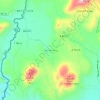
Name: San Nicolás topographic map, elevation, terrain.
Location: San Nicolás, Chalchuapa, Santa Ana, El Salvador (14.04951 -89.74581 14.08951 -89.70581)
Average elevation: 713 m
Minimum elevation: 585 m
Maximum elevation: 965 m
Thank you for supporting this site ❤️
Make a donation
Make a donation
Other topographic maps
Click on a map to view its topography, its elevation and its terrain.