
Make a donation
Lassa topographic map
Click on the map to display elevation.
Make a donation
Lassa
Lassa (Arabic: لاسا) is a municipality in the Byblos District of Keserwan-Jbeil Governorate, Lebanon. It is 90 kilometers north of Beirut. Lassa has an average elevation of 1,130 meters above sea level and a total land area of 739 hectares. The village contains one public school, which enrolled 15 students in 2008. Its inhabitants are predominantly Shia Muslims with a Maronite minority.
Make a donation
About this map
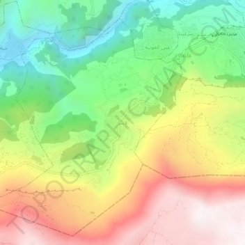
Name: Lassa topographic map, elevation, terrain.
Location: Lassa, Jbeil District, Keserwan-Jbeil Governorate, Lebanon (34.04842 35.83368 34.08842 35.87368)
Average elevation: 1,315 m
Minimum elevation: 739 m
Maximum elevation: 1,990 m
Make a donation
Other topographic maps
Click on a map to view its topography, its elevation and its terrain.
Faytroun
Lebanon > Keserwan-Jbeil Governorate
Faitroun (Arabic: فيطرون, romanized: Fayṭrūn; also spelled Faytroun) is a town in the Keserwan District of Keserwan-Jbeil Governorate. Located 33 kilometers north of Beirut and at an average altitude of 1,200 meters above sea level and its total land area of 743 hectares. Its inhabitants are…
Average elevation: 1,207 m
Make a donation
Make a donation
Make a donation
Make a donation
Make a donation
Make a donation
Mounsef
Lebanon > Keserwan-Jbeil Governorate
Mounsef (Arabic: المنصف, also spelled al-Mounsif) is a municipality in the Byblos District of Keserwan-Jbeil Governorate, Lebanon. It located off the Mediterranean coast and is 47 kilometers north of Beirut. Mounsef has an average elevation of 220 meters above sea level and a total land area of 341…
Average elevation: 127 m
Make a donation
Make a donation
Make a donation
Make a donation
Make a donation
Zouk Mosbeh
Lebanon > Keserwan-Jbeil Governorate
Zouk Mosbeh (Arabic: زوق مصبح) is a town and municipality in the Keserwan District of the Keserwan-Jbeil Governorate in Lebanon. It is located 12 kilometers north of Beirut. Zouk Mosbeh's average elevation is 170 meters above sea level and its total land area is 453 hectares. Its inhabitants are…
Average elevation: 114 m
Make a donation
Make a donation
Ghazir
Lebanon > Keserwan-Jbeil Governorate
Ghazir (Arabic: غزير) is a town and municipality in the Keserwan District of the Keserwan-Jbeil Governorate of Lebanon. It is located 27 kilometres (17 mi) north of Beirut. It has an average elevation of 380 meters above sea level and a total land area of 542 hectares (2.09 sq mi). The town has four…
Average elevation: 359 m
Make a donation
Make a donation