
Thank you for supporting this site ❤️
Make a donation
Make a donation
Ayegui topographic map
Click on the map to display elevation.
Thank you for supporting this site ❤️
Make a donation
Make a donation
About this map
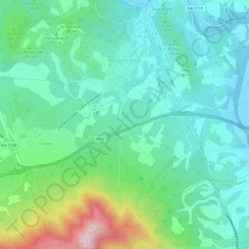
Name: Ayegui topographic map, elevation, terrain.
Location: Ayegui, Tierra Estella, España (42.62804 -2.07046 42.66853 -2.02549)
Average elevation: 558 m
Minimum elevation: 405 m
Maximum elevation: 1,029 m
Thank you for supporting this site ❤️
Make a donation
Make a donation
Other topographic maps
Click on a map to view its topography, its elevation and its terrain.