
Chone topographic map
Interactive map
Click on the map to display elevation.
About this map
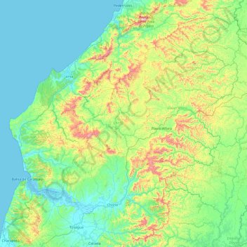
Name: Chone topographic map, elevation, terrain.
Location: Chone, Manabí, Ecuador (-0.85446 -80.28644 0.08837 -79.59709)
Average elevation: 160 m
Minimum elevation: -2 m
Maximum elevation: 759 m
Other topographic maps
Click on a map to view its topography, its elevation and its terrain.
La Estancilla
La Estancilla, Parroquia Angel Pedro Giler, Tosagua, Manabí, Ecuador
Average elevation: 16 m
Aguas Coloradas
Ecuador > Manabí > Chone > Chone
Aguas Coloradas, Chone, Manabí, Ecuador
Average elevation: 43 m