
Dussnang topographic map
Interactive map
Click on the map to display elevation.
About this map
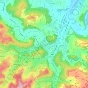
Name: Dussnang topographic map, elevation, terrain.
Location: Dussnang, Fischingen, Bezirk Münchwilen, Thurgau, 8374, Schweiz (47.41095 8.94111 47.45095 8.98111)
Average elevation: 650 m
Minimum elevation: 545 m
Maximum elevation: 836 m
Other topographic maps
Click on a map to view its topography, its elevation and its terrain.
Chuchi
Schweiz > Thurgau > Bezirk Münchwilen > Fischingen > Rotbühl
Chuchi, Rotbühl, Fischingen, Bezirk Münchwilen, Thurgau, 9645, Schweiz
Average elevation: 776 m
Obere Alp
Schweiz > Thurgau > Bezirk Münchwilen > Krillberg
Obere Alp, Krillberg, Wängi, Bezirk Münchwilen, Thurgau, 9546, Schweiz
Average elevation: 577 m
Guntershausen
Schweiz > Thurgau > Bezirk Münchwilen
Guntershausen, Aadorf, Bezirk Münchwilen, Thurgau, 8355, Schweiz
Average elevation: 596 m