
Thank you for supporting this site ❤️
Make a donation
Make a donation
Aspin-Aure topographic map
Click on the map to display elevation.
Thank you for supporting this site ❤️
Make a donation
Make a donation
About this map
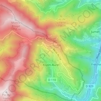
Name: Aspin-Aure topographic map, elevation, terrain.
Average elevation: 1,169 m
Minimum elevation: 661 m
Maximum elevation: 1,749 m
Thank you for supporting this site ❤️
Make a donation
Make a donation
Other topographic maps
Click on a map to view its topography, its elevation and its terrain.
Villenave
Франция > Окситания > Верхние Пиренеи > Luz-Saint-Sauveur > Villenave
Average elevation: 1,061 m