
Whitehall topographic map
Interactive map
Click on the map to display elevation.
About this map
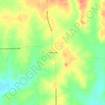
Name: Whitehall topographic map, elevation, terrain.
Location: Whitehall, Grimes County, Texas, United States (30.28243 -95.99357 30.32243 -95.95357)
Average elevation: 96 m
Minimum elevation: 69 m
Maximum elevation: 121 m
Other topographic maps
Click on a map to view its topography, its elevation and its terrain.
Plantersville
United States > Texas > Grimes County > Plantersville
Plantersville, Grimes County, Texas, United States
Average elevation: 102 m
Bedias
United States > Texas > Grimes County
Bedias, Grimes County, Texas, United States
Average elevation: 99 m
Navasota
United States > Texas > Grimes County
Navasota, Grimes County, Texas, 77868, United States
Average elevation: 71 m
Iola
United States > Texas > Grimes County
Iola, Grimes County, Texas, United States
Average elevation: 101 m
Navasota
United States > Texas > Grimes County > Navasota > Navasota
Navasota, Grimes County, Texas, 77868, United States
Average elevation: 71 m