
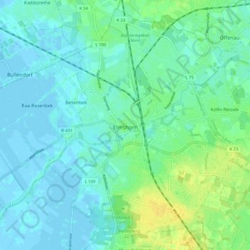
Elmshorn topographic map
Interactive map
Click on the map to display elevation.
About this map
Name: Elmshorn topographic map, elevation, terrain.
Location: Elmshorn, Kreis Pinneberg, Schleswig-Holstein, Deutschland (53.72609 9.62162 53.78130 9.72147)
Average elevation: 6 m
Minimum elevation: -3 m
Maximum elevation: 20 m
Elmshorn ist in fünf Quartiere unterteilt: Kaltenweide, Langelohe/Hainholz, Klostersande/Lieth, Fuchsberg und Mitte/Flamweg. Weitere Ortsteile sind Papenhöhe, Sibirien, Vosskuhlen, Langenmoor, Sandberg, Köhnholz, Ramskamp und Franzosenhof.