
Thank you for supporting this site ❤️
Make a donation
Make a donation
Bondokuy topographic map
Click on the map to display elevation.
Thank you for supporting this site ❤️
Make a donation
Make a donation
About this map
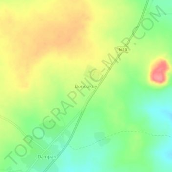
Name: Bondokuy topographic map, elevation, terrain.
Location: Bondokuy, Mouhoun, Schwarzer-Volta-Bogen, Burkina Faso (11.84696 -3.77205 11.88696 -3.73205)
Average elevation: 376 m
Minimum elevation: 338 m
Maximum elevation: 420 m
Thank you for supporting this site ❤️
Make a donation
Make a donation
Other topographic maps
Click on a map to view its topography, its elevation and its terrain.
Thank you for supporting this site ❤️
Make a donation
Make a donation
Thank you for supporting this site ❤️
Make a donation
Make a donation
Dourtenga
Dourtenga liegt auf dem vor mehr als zwei Milliarden Jahren entstandenen präkambrischen Granitsockel, der drei Viertel der Landesfläche ausmacht und einen Teil des Mittelabschnitts der Oberguineaschwelle darstellt. Das Relief dieser flachwelligen Hochebene ist durch Senken, Kuppen, Hügel und vereinzelte…
Average elevation: 284 m
Thank you for supporting this site ❤️
Make a donation
Make a donation
Thank you for supporting this site ❤️
Make a donation
Make a donation
Thank you for supporting this site ❤️
Make a donation
Make a donation
Thank you for supporting this site ❤️
Make a donation
Make a donation
Thank you for supporting this site ❤️
Make a donation
Make a donation