
Thank you for supporting this site ❤️
Make a donation
Make a donation
Padilla topographic map
Click on the map to display elevation.
Thank you for supporting this site ❤️
Make a donation
Make a donation
Padilla
Padilla is located in the transition zone between the Andean mountain range, the Cordillera Central and the Bolivian lowlands at an altitude of 2086 metres. The mean average temperature of the region is around 18 °C and varies only slightly between 14.5 °C in June and July and nearly 20 °C from November to January. The annual rainfall is about 650 mm, with a pronounced dry season from May to August.
Thank you for supporting this site ❤️
Make a donation
Make a donation
About this map
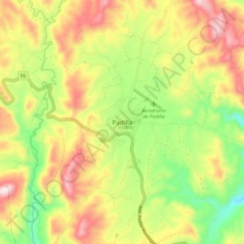
Name: Padilla topographic map, elevation, terrain.
Average elevation: 2,113 m
Minimum elevation: 1,987 m
Maximum elevation: 2,377 m
Thank you for supporting this site ❤️
Make a donation
Make a donation