
Thank you for supporting this site ❤️
Make a donation
Make a donation
Chicklade topographic map
Click on the map to display elevation.
Thank you for supporting this site ❤️
Make a donation
Make a donation
About this map
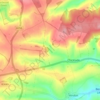
Name: Chicklade topographic map, elevation, terrain.
Location: Chicklade, Wiltshire, England, United Kingdom (51.10194 -2.18450 51.12753 -2.11562)
Average elevation: 181 m
Minimum elevation: 111 m
Maximum elevation: 236 m
Thank you for supporting this site ❤️
Make a donation
Make a donation