
Seia topographic map
Interactive map
Click on the map to display elevation.
About this map
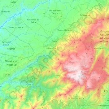
Name: Seia topographic map, elevation, terrain.
Location: Seia, Guarda, Portugal (40.22992 -7.84923 40.53552 -7.58343)
Average elevation: 754 m
Minimum elevation: 150 m
Maximum elevation: 1,989 m
The municipality is limited to the north by the municipalities of Nelas and Mangualde, to the northeast by Gouveia, to the east by Manteigas, to the southeast by Covilhã, to the southwest by Arganil and to the west by Oliveira do Hospital. In this municipality is located the highest point in mainland Portugal, Torre, in Serra da Estrela, with 1,993 meters of altitude. The municipality of Seia covers a large part of Serra da Estrela and is also the only one in Portugal where there is a natural ski resort, Vodafone Ski Resort, located within the limits of the parish of Loriga.
Other topographic maps
Click on a map to view its topography, its elevation and its terrain.