
Thank you for supporting this site ❤️
Make a donation
Make a donation
Tutnalls topographic map
Click on the map to display elevation.
Thank you for supporting this site ❤️
Make a donation
Make a donation
About this map
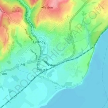
Name: Tutnalls topographic map, elevation, terrain.
Average elevation: 31 m
Minimum elevation: -1 m
Maximum elevation: 127 m
Thank you for supporting this site ❤️
Make a donation
Make a donation
Other topographic maps
Click on a map to view its topography, its elevation and its terrain.
Lydney Harbour
United Kingdom > England > Gloucestershire > Forest of Dean > Lydney > Naas
Average elevation: 7 m