
Thank you for supporting this site ❤️
Make a donation
Make a donation
Mount Telomoyo topographic map
Click on the map to display elevation.
Thank you for supporting this site ❤️
Make a donation
Make a donation
About this map
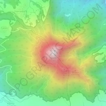
Name: Mount Telomoyo topographic map, elevation, terrain.
Average elevation: 1,390 m
Minimum elevation: 1,037 m
Maximum elevation: 1,869 m
Thank you for supporting this site ❤️
Make a donation
Make a donation
Other topographic maps
Click on a map to view its topography, its elevation and its terrain.
Lapangan Paripurno Kecamatan Salaman
Indonesia > Central Java > Magelang > Kembanglimus
Average elevation: 276 m
Thank you for supporting this site ❤️
Make a donation
Make a donation