
Make a donation
Rinjani topographic map
Click on the map to display elevation.
Make a donation
Rinjani
In September 1995 an aviation report was issued concerning an unconfirmed ash cloud from Rinjani. A NOTAM about volcanic activity from Rinjani was issued by the Bali Flight Information Region on the morning of 12 September. An ash cloud was reportedly drifting to the south west with the cloud top around 4 km (2.5 mi) altitude.
Make a donation
About this map
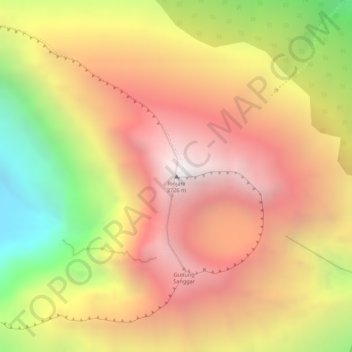
Name: Rinjani topographic map, elevation, terrain.
Average elevation: 3,071 m
Minimum elevation: 2,142 m
Maximum elevation: 3,685 m
Make a donation
Other topographic maps
Click on a map to view its topography, its elevation and its terrain.
Lombok
Indonesia > West Nusa Tenggara
The island's topography is dominated by the centrally-located stratovolcano Mount Rinjani, the second-highest volcano in Indonesia, which rises to 3,726 metres (12,224 ft), making Lombok the 8th-highest island. The most recent eruption of Rinjani occurred in September 2016 at Gunung Barujari. In a 2010…
Average elevation: 192 m
Make a donation
Lombok Tengah
Indonesia > West Nusa Tenggara
Central Lombok has a tropical climate with long dry seasons. The rain season normally commences in October and continues until April with an average rainfall of above 100mm during these months. In December falls have reached 382 mm. From May until September average rainfall is below 100 mm with the lowest…
Average elevation: 289 m
Make a donation
Lombok
Indonesia > West Nusa Tenggara
The island's topography is dominated by the centrally located stratovolcano Mount Rinjani, the second-highest volcano in Indonesia, which rises to 3,726 metres (12,224 ft), making Lombok the 8th-highest island. The most recent eruption of Rinjani occurred in September 2016 at Gunung Barujari. In a 2010…
Average elevation: 192 m
Make a donation
Make a donation
Lombok
Indonesia > West Nusa Tenggara
The island's topography is dominated by the centrally-located stratovolcano Mount Rinjani, the second-highest volcano in Indonesia, which rises to 3,726 metres (12,224 ft), making Lombok the 8th-highest island. The most recent eruption of Rinjani occurred in September 2016 at Gunung Barujari. In a 2010…
Average elevation: 192 m
Make a donation
Lombok Tengah
Indonesia > West Nusa Tenggara
Central Lombok has a tropical climate with long dry seasons. The rain season normally commences in October and continues until April with an average rainfall of above 100mm during these months. In December falls have reached 382 mm. From May until September average rainfall is below 100 mm with the lowest…
Average elevation: 289 m
Make a donation
Make a donation
Batas Dusun Kwang Pati 1
Indonesia > West Nusa Tenggara > Kabupaten Lombok Tengah > Batas Desa Lendang Ara
Average elevation: 403 m
Make a donation