
Make a donation
Leadville topographic map
Click on the map to display elevation.
Make a donation
Leadville
The City of Leadville is a statutory city that is the county seat, the most populous community, and the only incorporated municipality in Lake County, Colorado, United States. The city population was 2,602 at the 2010 census and an estimated 2,762 in 2018. It is situated at an elevation of 10,152 feet (3,094 m). Leadville is the highest incorporated city in the United States and it is surrounded by two of the tallest 14,000 foot peaks in the state.
Make a donation
About this map
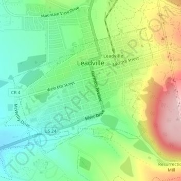
Name: Leadville topographic map, elevation, terrain.
Location: Leadville, Lake County, Colorado, 80461, United States (39.23730 -106.30754 39.26162 -106.27958)
Average elevation: 3,107 m
Minimum elevation: 3,023 m
Maximum elevation: 3,247 m
Make a donation
Other topographic maps
Click on a map to view its topography, its elevation and its terrain.
Mount Massive
United States > Colorado > Lake County
A class 2 hiking path leads to the peak from the eastern face. The path is 13.6 mi (21.9 km) round trip, with a 4,500 ft (1,400 m) elevation gain. There is also a class 2 route along the southwest slopes.
Average elevation: 4,021 m
Mount Massive
United States > Colorado > Lake County
A class 2 hiking path leads to the peak from the eastern face. The path is 13.6 mi (21.9 km) round trip, with a 4,500 ft (1,400 m) elevation gain. There is also a class 2 route along the southwest slopes.
Average elevation: 4,021 m
Make a donation
Mount Elbert
United States > Colorado > Lake County
Mount Elbert is the highest summit of the Rocky Mountains of North America. With an elevation of 14,438 feet (4400.58 m), it is also the highest point in the U.S. state of Colorado and the second-highest summit in the contiguous United States after Mount Whitney, which is slightly taller. The ultra-prominent…
Average elevation: 3,959 m
Independence Pass
United States > Colorado > Lake County
Independence Pass, originally known as Hunter Pass, is a high mountain pass in central Colorado, United States. It is at elevation 12,095 ft (3,687 m) on the Continental Divide in the Sawatch Range of the Rocky Mountains. The pass is midway between Aspen and Twin Lakes, on the border between Pitkin and Lake…
Average elevation: 3,627 m
Mount Elbert
United States > Colorado > Lake County
Mount Elbert is composed largely of quartzite. However, the summit ridge consists of metamorphic basement rock, which is Pre-Cambrian in origin and about 1.7 billion years old. There are various igneous intrusions including pegmatite, as well as bands of gneiss and schist. Unlike mountains of similar altitude…
Average elevation: 3,959 m
Make a donation