
Thank you for supporting this site ❤️
Make a donation
Make a donation
Bratsberg topographic map
Click on the map to display elevation.
Thank you for supporting this site ❤️
Make a donation
Make a donation
About this map
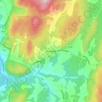
Name: Bratsberg topographic map, elevation, terrain.
Location: Bratsberg, Trondheim, Trøndelag, Norge (63.32930 10.46244 63.36930 10.50244)
Average elevation: 196 m
Minimum elevation: 65 m
Maximum elevation: 413 m
Thank you for supporting this site ❤️
Make a donation
Make a donation
Other topographic maps
Click on a map to view its topography, its elevation and its terrain.