
Thank you for supporting this site ❤️
Make a donation
Make a donation
Le Pessy topographic map
Click on the map to display elevation.
Thank you for supporting this site ❤️
Make a donation
Make a donation
About this map
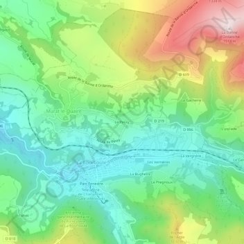
Name: Le Pessy topographic map, elevation, terrain.
Average elevation: 1,052 m
Minimum elevation: 829 m
Maximum elevation: 1,477 m
Thank you for supporting this site ❤️
Make a donation
Make a donation
Other topographic maps
Click on a map to view its topography, its elevation and its terrain.
Banne d'Ordanche
France > Auvergne-Rhône-Alpes > Puy-de-Dôme > Murat-le-Quaire
Average elevation: 1,270 m