
Thank you for supporting this site ❤️
Make a donation
Make a donation
Pu Chei (Lower) topographic map
Click on the map to display elevation.
Thank you for supporting this site ❤️
Make a donation
Make a donation
About this map
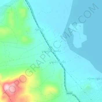
Name: Pu Chei (Lower) topographic map, elevation, terrain.
Average elevation: 926 m
Minimum elevation: 879 m
Maximum elevation: 1,133 m
Thank you for supporting this site ❤️
Make a donation
Make a donation
Other topographic maps
Click on a map to view its topography, its elevation and its terrain.
Thank you for supporting this site ❤️
Make a donation
Make a donation
Pinlaung Township
Myanmar > Shan State > Taunggyi District > Pinlaung Township
Pinlaung Township accounts for the largest area of tea cultivation in southern Shan State. The Tea grown here is of the Assamica cultivar. Tea plantations in the area cover 12,000 acres, with half of the cultivation taking place in the higher elevations of Le Hlaung, 10 miles from Pinlaung. In the Koe Khaung…
Average elevation: 964 m