
Raglan topographic map
Interactive map
Click on the map to display elevation.
About this map
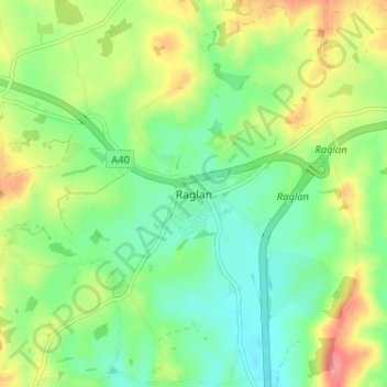
Name: Raglan topographic map, elevation, terrain.
Location: Raglan, Monmouthshire, Wales, NP15 2DR, United Kingdom (51.74505 -2.87406 51.78505 -2.83406)
Average elevation: 60 m
Minimum elevation: 27 m
Maximum elevation: 115 m
Other topographic maps
Click on a map to view its topography, its elevation and its terrain.
Caldicot
United Kingdom > Wales > Monmouthshire
Caldicot, Monmouthshire, Wales, NP26 4BW, United Kingdom
Average elevation: 21 m
Crick
United Kingdom > Wales > Monmouthshire
Crick, Monmouthshire, Wales, NP26 5UW, United Kingdom
Average elevation: 29 m
Abergavenny
United Kingdom > Wales > Monmouthshire
Abergavenny, Monmouthshire, Wales, NP7 5NQ, United Kingdom
Average elevation: 187 m