
Thank you for supporting this site ❤️
Make a donation
Make a donation
Bayer topographic map
Click on the map to display elevation.
Thank you for supporting this site ❤️
Make a donation
Make a donation
About this map
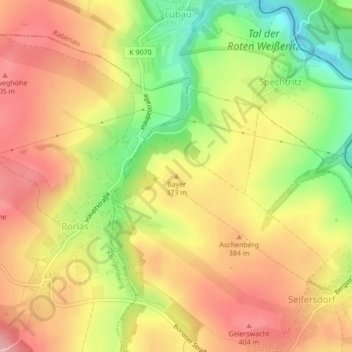
Name: Bayer topographic map, elevation, terrain.
Average elevation: 359 m
Minimum elevation: 281 m
Maximum elevation: 416 m
Thank you for supporting this site ❤️
Make a donation
Make a donation
Other topographic maps
Click on a map to view its topography, its elevation and its terrain.
Talsperre Malter
Deutschland > Sachsen > Sächsische Schweiz-Osterzgebirge > Dippoldiswalde > Malter
Average elevation: 368 m
Dippoldiswalde
Deutschland > Sachsen > Sächsische Schweiz-Osterzgebirge > Dippoldiswalde
Average elevation: 446 m
01744
Deutschland > Sachsen > Sächsische Schweiz-Osterzgebirge > Dippoldiswalde
Average elevation: 498 m