
Thank you for supporting this site ❤️
Make a donation
Make a donation
Vilangad topographic map
Click on the map to display elevation.
Thank you for supporting this site ❤️
Make a donation
Make a donation
About this map
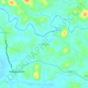
Name: Vilangad topographic map, elevation, terrain.
Location: Vilangad, Vadakara, Kozhikode, Kerala, 673504, India (11.67768 75.64702 11.71768 75.68702)
Average elevation: 27 m
Minimum elevation: 7 m
Maximum elevation: 104 m
Thank you for supporting this site ❤️
Make a donation
Make a donation
Other topographic maps
Click on a map to view its topography, its elevation and its terrain.
Thiruvancheri Chira, Santhi Nagar at Valakettu
India > Kerala > Vadakara > Velom
Average elevation: 15 m