
Make a donation
Gunung Datuk topographic map
Click on the map to display elevation.
Make a donation
Gunung Datuk
The main highlight of the mountain is a tor that consists of massive granite boulders, at the elevation of 855 m (2,805 ft).
Make a donation
About this map
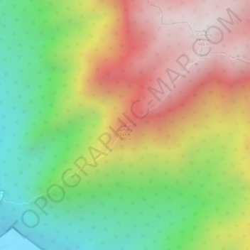
Name: Gunung Datuk topographic map, elevation, terrain.
Location: Gunung Datuk, Rembau, Negeri Sembilan, 71350, Malaysia (2.55082 102.18252 2.55092 102.18262)
Average elevation: 450 m
Minimum elevation: 37 m
Maximum elevation: 866 m
Make a donation
Other topographic maps
Click on a map to view its topography, its elevation and its terrain.
Make a donation
Make a donation
Make a donation
Make a donation
Perkampungan Budaya Terachi
Malaysia > Negeri Sembilan > Kampung Ayer Hitam > Kampung Parit Istana
Average elevation: 128 m
Make a donation
Jelebu
Amongst the seven districts of Negeri Sembilan, Jelebu is the most mountainous topographically as the Titiwangsa Mountains, the longest mountain range in Malaysia, transverses through the district. As a result, most of its terrain are dominated by forested undulating hills and mountain peaks. The Titiwangsa…
Average elevation: 307 m
Make a donation
Make a donation
Make a donation
Make a donation
Make a donation
Make a donation
Make a donation