
Thank you for supporting this site ❤️
Make a donation
Make a donation
Parque Universitario topographic map
Click on the map to display elevation.
Thank you for supporting this site ❤️
Make a donation
Make a donation
About this map
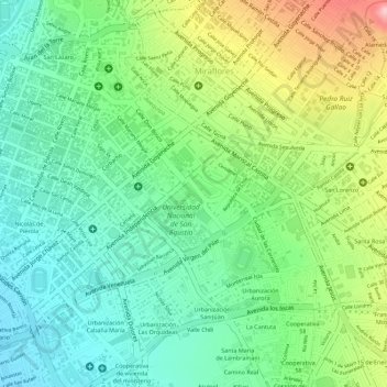
Name: Parque Universitario topographic map, elevation, terrain.
Location: Parque Universitario, Urbanización Aurora, Arequipa, Perú (-16.40371 -71.52445 -16.40181 -71.52303)
Average elevation: 2,380 m
Minimum elevation: 2,312 m
Maximum elevation: 2,496 m
Thank you for supporting this site ❤️
Make a donation
Make a donation
Other topographic maps
Click on a map to view its topography, its elevation and its terrain.