
Thank you for supporting this site ❤️
Make a donation
Make a donation
Neuhonrath topographic map
Click on the map to display elevation.
Thank you for supporting this site ❤️
Make a donation
Make a donation
Neuhonrath
Neuhonrath liegt im Norden der Stadt Lohmar. Umliegende Ortschaften und Weiler sind Agger und Naafshäuschen im Nordwesten, Honsbach und Hohnenberg im Norden, Hähngen, Holl, Oberstehöhe und Grünenborn im Osten, Saal und Heide (bei Höffen) im Südosten, Höffen, Schönenberg und Wahlscheid im Süden und Bachermühle und Windlöck im Westen. Neuhonrath liegt wie Wahlscheid auch im Aggertal und ist von bewaldeten Berghängen umgeben.
Thank you for supporting this site ❤️
Make a donation
Make a donation
About this map
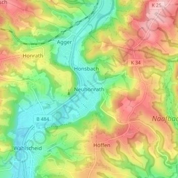
Name: Neuhonrath topographic map, elevation, terrain.
Average elevation: 147 m
Minimum elevation: 68 m
Maximum elevation: 243 m
Thank you for supporting this site ❤️
Make a donation
Make a donation
Other topographic maps
Click on a map to view its topography, its elevation and its terrain.