
Make a donation
Harz topographic map
Click on the map to display elevation.
Make a donation
Harz
The Harz (German: [haːɐ̯ts] ) is a highland area in northern Germany. It has the highest elevations for that region, and its rugged terrain extends across parts of Lower Saxony, Saxony-Anhalt, and Thuringia. The name Harz derives from the Middle High German word Hardt or Hart (hill forest). The name Hercynia derives from a Celtic name and could refer to other mountain forests, but has also been applied to the geology of the Harz. The Brocken is the highest summit in the Harz with an elevation of 1,141.1 metres (3,744 ft) above sea level. The Wurmberg (971 metres (3,186 ft)) is the highest peak located entirely within the state of Lower Saxony.
Make a donation
About this map
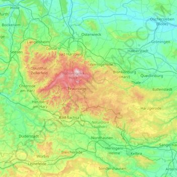
Name: Harz topographic map, elevation, terrain.
Location: Harz, Saxony-Anhalt, Germany (51.49477 10.18402 51.95506 11.46491)
Average elevation: 280 m
Minimum elevation: 75 m
Maximum elevation: 1,139 m
Make a donation
Other topographic maps
Click on a map to view its topography, its elevation and its terrain.
Dessau
Germany > Saxony-Anhalt > Dessau-Roßlau
Dessau is situated on a floodplain where the Mulde flows into the Elbe. This causes yearly floods. The worst flood took place in the year 2002, when the Waldersee district was nearly completely flooded. The south of Dessau touches a well-wooded area called Mosigkauer Heide. The highest elevation is a 110 m…
Average elevation: 62 m
Brocken
Germany > Saxony-Anhalt > Landkreis Harz > Wernigerode
The Brocken (German pronunciation: [ˈbʁɔkn̩] ), also sometimes referred to as the Blocksberg, is a 1,141 m (3,743 ft) mountain near Schierke in the German state of Saxony-Anhalt, between the rivers Weser and Elbe. The highest peak in the Harz mountain range, and in Northern Germany, it is subalpine, yet…
Average elevation: 963 m
Make a donation
Make a donation
Tromsdorf
Germany > Saxony-Anhalt > Burgenlandkreis > Eckartsberga > Tromsdorf
Average elevation: 195 m
Make a donation
Aschersleben
Germany > Saxony-Anhalt > Salzlandkreis > Aschersleben > Aschersleben
Average elevation: 139 m
Make a donation