
Thank you for supporting this site ❤️
Make a donation
Make a donation
Gurten topographic map
Click on the map to display elevation.
Thank you for supporting this site ❤️
Make a donation
Make a donation
About this map
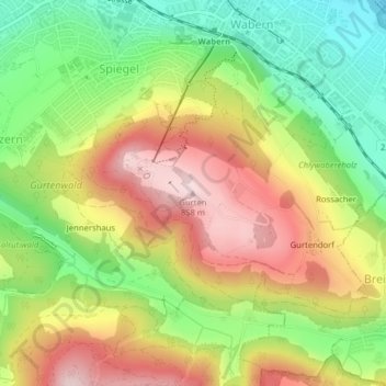
Name: Gurten topographic map, elevation, terrain.
Average elevation: 677 m
Minimum elevation: 511 m
Maximum elevation: 859 m
Thank you for supporting this site ❤️
Make a donation
Make a donation
Other topographic maps
Click on a map to view its topography, its elevation and its terrain.
Spiegel bei Bern
Suisse > Berne > Arrondissement administratif de Berne-Mittelland > Köniz
Average elevation: 630 m
Niederscherli
Suisse > Berne > Arrondissement administratif de Berne-Mittelland > Köniz
Average elevation: 705 m