
Thank you for supporting this site ❤️
Make a donation
Make a donation
Ban Du topographic map
Click on the map to display elevation.
Thank you for supporting this site ❤️
Make a donation
Make a donation
About this map
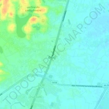
Name: Ban Du topographic map, elevation, terrain.
Location: Ban Du, Nang Lae, Chiang Rai Province, 57100, Thailand (19.94790 99.83723 19.98790 99.87723)
Average elevation: 392 m
Minimum elevation: 384 m
Maximum elevation: 418 m
Thank you for supporting this site ❤️
Make a donation
Make a donation
Other topographic maps
Click on a map to view its topography, its elevation and its terrain.