
Thank you for supporting this site ❤️
Make a donation
Make a donation
Montpon topographic map
Click on the map to display elevation.
Thank you for supporting this site ❤️
Make a donation
Make a donation
About this map
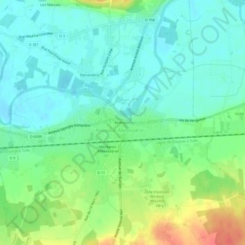
Name: Montpon topographic map, elevation, terrain.
Average elevation: 43 m
Minimum elevation: 25 m
Maximum elevation: 83 m
Thank you for supporting this site ❤️
Make a donation
Make a donation
Other topographic maps
Click on a map to view its topography, its elevation and its terrain.
24700
France > Nouvelle-Aquitaine > Dordogne > Montpon-Ménestérol > Les Grillauds
Average elevation: 64 m