
Make a donation
Riofreddo topographic map
Click on the map to display elevation.
Make a donation
About this map
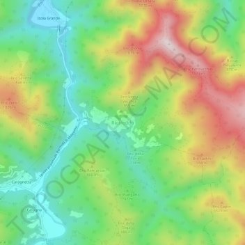
Name: Riofreddo topographic map, elevation, terrain.
Location: Riofreddo, Murialdo, Savona, Liguria, Italy (44.25780 8.11776 44.29780 8.15776)
Average elevation: 816 m
Minimum elevation: 566 m
Maximum elevation: 1,193 m
Make a donation
Other topographic maps
Click on a map to view its topography, its elevation and its terrain.
Bormida
Bormida is about 20 kilometres (12 mi) west of Savona (as the crow flies) in the upper Val Bormida between the mountain peaks of Settepani, elevation 1,386 metres (4,547 ft), and Ronco di Maglio, elevation 1,108 metres (3,635 ft). The Bormida di Pallare, a tributary of the Bormida di Spigno, flows through its…
Average elevation: 793 m
Make a donation
Make a donation
Make a donation
Make a donation
Make a donation
Bormida
Bormida is about 20 kilometres (12 mi) west of Savona (as the crow flies) in the upper Val Bormida between the mountain peaks of Settepani, elevation 1,386 metres (4,547 ft), and Ronco di Maglio, elevation 1,108 metres (3,635 ft). The Bormida di Pallare, a tributary of the Bormida di Spigno, flows through its…
Average elevation: 793 m
Make a donation
Make a donation
Make a donation
Make a donation