
Make a donation
Red Rock Canyon topographic map
Click on the map to display elevation.
Make a donation
About this map
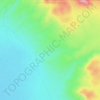
Name: Red Rock Canyon topographic map, elevation, terrain.
Average elevation: 399 m
Minimum elevation: 348 m
Maximum elevation: 513 m
Make a donation
Other topographic maps
Click on a map to view its topography, its elevation and its terrain.
San Francisco
United States of America > California
Because of its sharp topography and maritime influences, San Francisco exhibits a multitude of distinct microclimates. The high hills in the geographic center of the city are responsible for a 20% variance in annual rainfall between different parts of the city. They also protect neighborhoods directly to their…
Average elevation: 57 m
Scripps Ranch
United States of America > California > San Diego > Scripps Ranch
Average elevation: 193 m
Make a donation
Pine Mountain Club
United States of America > California
Pine Mountain Club has an area of 16.7 square miles (43.25 km2). It ranges from 4,901 to 6,400 feet (1,494 to 1,951 m) in elevation.
Average elevation: 1,754 m
Salton Sea
United States of America > California > Salton City
The lake occupies the lowest elevations of the Salton Sink in the Colorado Desert of Imperial and Riverside counties in Southern California. Its surface is 236.0 ft (71.9 m) below sea level as of January 2018. The deepest point of the sea is 5 ft (1.5 m) higher than the lowest point of Death Valley. The sea is…
Average elevation: 17 m
Make a donation