
Make a donation
Fountain Hill topographic map
Click on the map to display elevation.
Make a donation
About this map
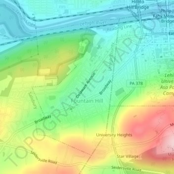
Name: Fountain Hill topographic map, elevation, terrain.
Location: Fountain Hill, Lehigh County, Pennsylvania, United States (40.59302 -75.40648 40.61422 -75.38859)
Average elevation: 147 m
Minimum elevation: 63 m
Maximum elevation: 297 m
Make a donation
Other topographic maps
Click on a map to view its topography, its elevation and its terrain.
Hensingersville
United States > Pennsylvania > Lehigh County > Lower Macungie Township
Average elevation: 203 m
Bake Oven Knob
United States > Pennsylvania > Lehigh County > Heidelberg Township
Average elevation: 310 m
Walbert
United States > Pennsylvania > Lehigh County > South Whitehall Township
Average elevation: 137 m
Make a donation
Old Zionsville
United States > Pennsylvania > Lehigh County > Upper Milford Township
Average elevation: 217 m
Laurys Station
United States > Pennsylvania > Lehigh County > North Whitehall Township
Average elevation: 152 m
Neffs
United States > Pennsylvania > Lehigh County > North Whitehall Township
Average elevation: 208 m
Make a donation
Metamora Station
United States > Pennsylvania > Lehigh County > South Whitehall Township > Metamora Station
Average elevation: 125 m
Crackersport
United States > Pennsylvania > Lehigh County > South Whitehall Township
Average elevation: 138 m
Milford Park
United States > Pennsylvania > Lehigh County > Upper Milford Township
Average elevation: 221 m
Make a donation