
Thank you for supporting this site ❤️
Make a donation
Make a donation
Gackerstein topographic map
Click on the map to display elevation.
Thank you for supporting this site ❤️
Make a donation
Make a donation
About this map
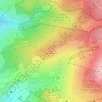
Name: Gackerstein topographic map, elevation, terrain.
Average elevation: 604 m
Minimum elevation: 458 m
Maximum elevation: 752 m
Thank you for supporting this site ❤️
Make a donation
Make a donation
Other topographic maps
Click on a map to view its topography, its elevation and its terrain.
Blockfelder am Taufstein
Deutschland > Hessen > Vogelsbergkreis > Breungeshain
Der Taufstein ist mit 773 m ü. NHN der höchste Gipfel im Vogelsberg. Er befindet sich bei Breungeshain im hessischen Vogelsbergkreis. Trotz einer beachtlichen Dominanz von 43 km und einer Schartenhöhe von 406 m fällt der Taufstein als Einzelberg kaum auf, da er aus der Gesamterhebung des Vogelsbergs nur…
Average elevation: 705 m