
Kaarst topographic map
Interactive map
Click on the map to display elevation.
About this map
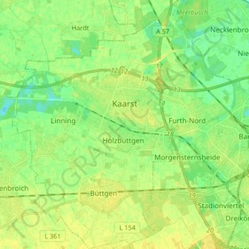
Name: Kaarst topographic map, elevation, terrain.
Location: Kaarst, Rhein-Kreis Neuss, Noordrijn-Westfalen, 41564, Duitsland (51.17849 6.55934 51.26093 6.67587)
Average elevation: 41 m
Minimum elevation: 31 m
Maximum elevation: 50 m
Other topographic maps
Click on a map to view its topography, its elevation and its terrain.
Minkel 2
Duitsland > Noordrijn-Westfalen > Rhein-Kreis Neuss > Neuss > Helpenstein
Minkel 2, Holzheim, Helpenstein, Neuss, Rhein-Kreis Neuss, Noordrijn-Westfalen, 41472, Duitsland
Average elevation: 50 m
Meerbusch
Duitsland > Noordrijn-Westfalen > Rhein-Kreis Neuss
Meerbusch, Rhein-Kreis Neuss, Noordrijn-Westfalen, Duitsland
Average elevation: 36 m
Deelen
Duitsland > Noordrijn-Westfalen > Rhein-Kreis Neuss > Rommerskirchen > Deelen
Deelen, Rommerskirchen, Rhein-Kreis Neuss, Noordrijn-Westfalen, 41569, Duitsland
Average elevation: 67 m