
Thank you for supporting this site ❤️
Make a donation
Make a donation
Memphis topographic map
Click on the map to display elevation.
Thank you for supporting this site ❤️
Make a donation
Make a donation
About this map
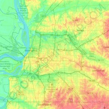
Name: Memphis topographic map, elevation, terrain.
Location: Memphis, Shelby County, Tennessee, 3813, United States (34.98902 -90.21163 35.30902 -89.89163)
Average elevation: 78 m
Minimum elevation: 54 m
Maximum elevation: 133 m
Thank you for supporting this site ❤️
Make a donation
Make a donation
Other topographic maps
Click on a map to view its topography, its elevation and its terrain.