
Thank you for supporting this site ❤️
Make a donation
Make a donation
Mae Sot topographic map
Click on the map to display elevation.
Thank you for supporting this site ❤️
Make a donation
Make a donation
About this map
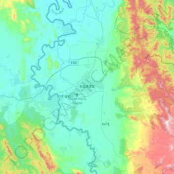
Name: Mae Sot topographic map, elevation, terrain.
Location: Mae Sot, Mae Tao, Mae Sot, Tak Province, 63110, Thailand (16.55499 98.40955 16.87499 98.72955)
Average elevation: 339 m
Minimum elevation: 170 m
Maximum elevation: 920 m
Thank you for supporting this site ❤️
Make a donation
Make a donation
Other topographic maps
Click on a map to view its topography, its elevation and its terrain.