
Leuven topographic map
Interactive map
Click on the map to display elevation.
About this map
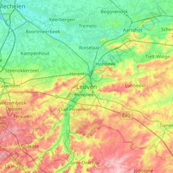
Name: Leuven topographic map, elevation, terrain.
Location: Leuven, Flemish Brabant, Flanders, 3000, Belgium (50.71920 4.54117 51.03920 4.86117)
Average elevation: 50 m
Minimum elevation: -1 m
Maximum elevation: 140 m
Other topographic maps
Click on a map to view its topography, its elevation and its terrain.
Wilsele
Belgium > Flemish Brabant > Leuven > Leuven
Wilsele, Leuven, Flemish Brabant, Flanders, 3012, Belgium
Average elevation: 25 m
Heverlee
Belgium > Flemish Brabant > Leuven > Leuven
Heverlee, Leuven, Flemish Brabant, Flanders, 3001, Belgium
Average elevation: 49 m