
Thank you for supporting this site ❤️
Make a donation
Make a donation
Mallas topographic map
Click on the map to display elevation.
Thank you for supporting this site ❤️
Make a donation
Make a donation
About this map
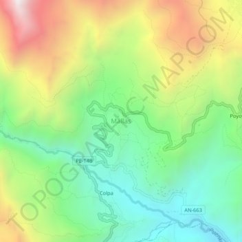
Name: Mallas topographic map, elevation, terrain.
Location: Mallas, Huari, Áncash, Perú (-9.42288 -77.21052 -9.38288 -77.17052)
Average elevation: 3,335 m
Minimum elevation: 2,780 m
Maximum elevation: 4,209 m
Thank you for supporting this site ❤️
Make a donation
Make a donation
Other topographic maps
Click on a map to view its topography, its elevation and its terrain.