
Thank you for supporting this site ❤️
Make a donation
Make a donation
Pfullendorf topographic map
Click on the map to display elevation.
Thank you for supporting this site ❤️
Make a donation
Make a donation
Pfullendorf
Die Stadt Pfullendorf liegt in topographischer Hanglage, rund 20 Kilometer nördlich des Bodensees im hügeligen Gelände des Linzgaus.
Thank you for supporting this site ❤️
Make a donation
Make a donation
About this map
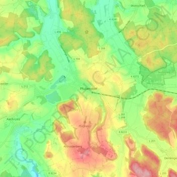
Name: Pfullendorf topographic map, elevation, terrain.
Average elevation: 655 m
Minimum elevation: 584 m
Maximum elevation: 746 m
Thank you for supporting this site ❤️
Make a donation
Make a donation