
Make a donation
Bosco topographic map
Click on the map to display elevation.
Make a donation
About this map
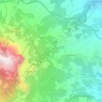
Name: Bosco topographic map, elevation, terrain.
Location: Bosco, San Giovanni a Piro, Salerno, Campania, Italy (40.05289 15.43712 40.09289 15.47712)
Average elevation: 388 m
Minimum elevation: 22 m
Maximum elevation: 1,217 m
Make a donation
Other topographic maps
Click on a map to view its topography, its elevation and its terrain.
Positano
Positano’s physical geography is defined by its steep, cliffside setting along the Amalfi Coast, where pastel-colored buildings appear to cascade down toward the Tyrrhenian Sea. The town is built on rugged limestone slopes of the Lattari Mountains, creating a “vertical village” layout with narrow…
Average elevation: 244 m
Make a donation
Positano
Positano’s physical geography is defined by its steep, cliffside setting along the Amalfi Coast, where pastel-colored buildings appear to cascade down toward the Tyrrhenian Sea. The town is built on rugged limestone slopes of the Lattari Mountains, creating a "vertical village" layout with narrow stairways…
Average elevation: 244 m
Make a donation
Make a donation
Positano
Positano’s physical geography is defined by its steep, cliffside setting along the Amalfi Coast, where pastel-colored buildings appear to cascade down toward the Tyrrhenian Sea. The town is built on rugged limestone slopes of the Lattari Mountains, creating a “vertical village” layout with narrow…
Average elevation: 244 m
Make a donation
Make a donation
Make a donation
Make a donation