
Thank you for supporting this site ❤️
Make a donation
Make a donation
Hjelset topographic map
Click on the map to display elevation.
Thank you for supporting this site ❤️
Make a donation
Make a donation
About this map
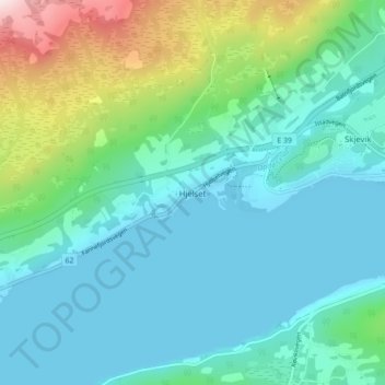
Name: Hjelset topographic map, elevation, terrain.
Location: Hjelset, Molde, Мёре-ог-Ромсдал, 6450, Норвегия (62.76143 7.47747 62.80143 7.51747)
Average elevation: 111 m
Minimum elevation: -1 m
Maximum elevation: 534 m
Thank you for supporting this site ❤️
Make a donation
Make a donation
Other topographic maps
Click on a map to view its topography, its elevation and its terrain.