
Thank you for supporting this site ❤️
Make a donation
Make a donation
Landrienne topographic map
Click on the map to display elevation.
Thank you for supporting this site ❤️
Make a donation
Make a donation
About this map
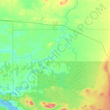
Name: Landrienne topographic map, elevation, terrain.
Location: Landrienne, Abitibi, Abitibi-Témiscamingue, Québec, Canada (48.43044 -78.01411 48.58821 -77.76911)
Average elevation: 321 m
Minimum elevation: 292 m
Maximum elevation: 395 m
Thank you for supporting this site ❤️
Make a donation
Make a donation
Other topographic maps
Click on a map to view its topography, its elevation and its terrain.