
Indre-et-Loire topographic map
Interactive map
Click on the map to display elevation.
About this map
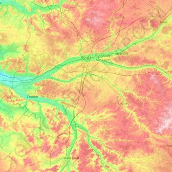
Name: Indre-et-Loire topographic map, elevation, terrain.
Location: Indre-et-Loire, Centre-Val de Loire, Metropolitan France, France (46.73666 0.05276 47.70979 1.36594)
Average elevation: 98 m
Minimum elevation: 24 m
Maximum elevation: 198 m
Other topographic maps
Click on a map to view its topography, its elevation and its terrain.