
Thank you for supporting this site ❤️
Make a donation
Make a donation
Point Imperial topographic map
Click on the map to display elevation.
Thank you for supporting this site ❤️
Make a donation
Make a donation
About this map
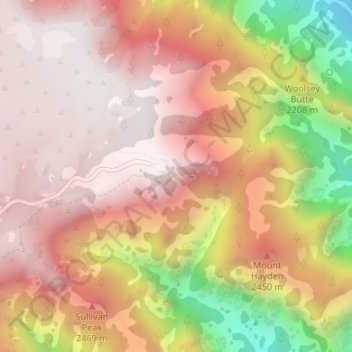
Name: Point Imperial topographic map, elevation, terrain.
Location: Point Imperial, Coconino County, Arizona, United States (36.27827 -111.97772 36.27837 -111.97762)
Average elevation: 2,323 m
Minimum elevation: 1,574 m
Maximum elevation: 2,709 m
Thank you for supporting this site ❤️
Make a donation
Make a donation
Other topographic maps
Click on a map to view its topography, its elevation and its terrain.
Grand Canyon Village
United States > Arizona > Coconino County > Grand Canyon Village
Average elevation: 1,666 m