
Thank you for supporting this site ❤️
Make a donation
Make a donation
Balite I topographic map
Click on the map to display elevation.
Thank you for supporting this site ❤️
Make a donation
Make a donation
About this map
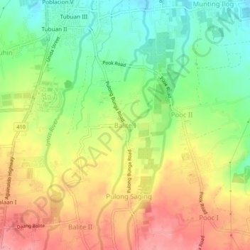
Name: Balite I topographic map, elevation, terrain.
Location: Balite I, Silang, Cavite, Calabarzon, 4118, Philippines (14.17955 120.96150 14.21955 121.00150)
Average elevation: 361 m
Minimum elevation: 310 m
Maximum elevation: 414 m
Thank you for supporting this site ❤️
Make a donation
Make a donation
Other topographic maps
Click on a map to view its topography, its elevation and its terrain.