
Brevard topographic map
Interactive map
Click on the map to display elevation.
About this map
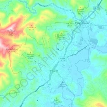
Name: Brevard topographic map, elevation, terrain.
Average elevation: 745 m
Minimum elevation: 633 m
Maximum elevation: 1,167 m
Other topographic maps
Click on a map to view its topography, its elevation and its terrain.
Quebec
États-Unis d'Amérique > Caroline du Nord > Transylvania County
Quebec, Transylvania County, Caroline du Nord, 28747, États-Unis d'Amérique
Average elevation: 819 m