
Ouder-Amstel topographic map
Interactive map
Click on the map to display elevation.
About this map
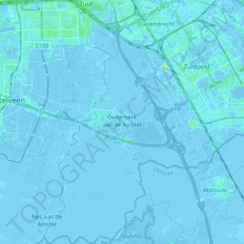
Name: Ouder-Amstel topographic map, elevation, terrain.
Location: Ouder-Amstel, Nordholland, Niederlande (52.25074 4.87012 52.33864 4.95524)
Average elevation: -1 m
Minimum elevation: -8 m
Maximum elevation: 19 m
Other topographic maps
Click on a map to view its topography, its elevation and its terrain.
Ouderkerk aan de Amstel
Niederlande > Nordholland > Ouder-Amstel
Ouderkerk aan de Amstel, Ouder-Amstel, Nordholland, Niederlande
Average elevation: -1 m