
Make a donation
Dörna topographic map
Click on the map to display elevation.
Make a donation
About this map
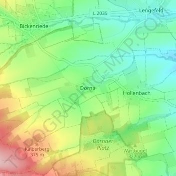
Name: Dörna topographic map, elevation, terrain.
Average elevation: 313 m
Minimum elevation: 250 m
Maximum elevation: 427 m
Make a donation
Other topographic maps
Click on a map to view its topography, its elevation and its terrain.
Mühlhausen/Thüringen
Deutschland > Thüringen > Unstrut-Hainich-Kreis
Nachbargemeinden sind Unstruttal im Norden, Nottertal-Heilinger Höhen und Körner im Osten, Unstrut-Hainich und Vogtei im Süden sowie Dingelstädt und Südeichsfeld im Westen.
Average elevation: 295 m
Oppershausen
Deutschland > Thüringen > Unstrut-Hainich-Kreis
Bad Langensalza | Bad Tennstedt | Ballhausen | Blankenburg | Bruchstedt | Großvargula | Haussömmern | Herbsleben | Hornsömmern | Kammerforst | Kirchheilingen | Körner | Kutzleben | Marolterode | Mittelsömmern | Mühlhausen/Thüringen | Nottertal-Heilinger Höhen | Oppershausen | Südeichsfeld | Sundhausen…
Average elevation: 263 m
Nottertal-Heilinger Höhen
Deutschland > Thüringen > Unstrut-Hainich-Kreis
Zum 31. Dezember 2019 wurde die Verwaltungsgemeinschaft aufgelöst und Bothenheilingen, Issersheilingen, Kleinwelsbach, Neunheilingen, Obermehler und Schlotheim bildeten die Stadt und Landgemeinde Nottertal-Heilinger Höhen, die erfüllende Gemeinde für Körner und Marolterode wurde.
Average elevation: 273 m
Bad Langensalza
Deutschland > Thüringen > Unstrut-Hainich-Kreis
Bad Langensalza liegt im Thüringer Becken, dem fruchtbaren Tiefland entlang der Unstrut. Durch die Stadt selbst fließt die Salza, die etwa zwei Kilometer östlich der Stadt in die Unstrut mündet. Bad Langensalza liegt in einer unbewaldeten, intensiv landwirtschaftlich genutzten flach-welligen Landschaft,…
Average elevation: 260 m
Make a donation
Weinbergen
Deutschland > Thüringen > Unstrut-Hainich-Kreis > Mühlhausen
Die Gemeinde Weinbergen schloss im Nordwesten an das Stadtgebiet von Mühlhausen/Thüringen an. Im Nordosten grenzte sie an Körner, im Südosten an die Verwaltungsgemeinschaft Unstrut-Hainich und im Westen an die Landgemeinde Vogtei. Das Gemeindegebiet lag in der Höhenlage zwischen 182 m ü. NN an der…
Average elevation: 223 m
Nationalpark Hainich
Deutschland > Thüringen > Unstrut-Hainich-Kreis > Weberstedt
Average elevation: 345 m
Make a donation
Urleben
Deutschland > Thüringen > Unstrut-Hainich-Kreis
Bad Langensalza | Bad Tennstedt | Ballhausen | Blankenburg | Bruchstedt | Großvargula | Haussömmern | Herbsleben | Hornsömmern | Kammerforst | Kirchheilingen | Körner | Kutzleben | Marolterode | Mittelsömmern | Mühlhausen/Thüringen | Nottertal-Heilinger Höhen | Oppershausen | Südeichsfeld | Sundhausen…
Average elevation: 214 m
Unstruttal
Deutschland > Thüringen > Unstrut-Hainich-Kreis
Im Süden und Osten grenzt Unstruttal an die Stadt Mühlhausen/Thüringen, im Südosten an die Stadt Nottertal-Heilinger Höhen, im Südwesten an die Gemeinde Rodeberg, im Westen an die Stadt Dingelstädt und im Norden an die Gemeinden Niederorschel und Helbedündorf.
Average elevation: 342 m
Marolterode
Deutschland > Thüringen > Unstrut-Hainich-Kreis
Marolterode ist eine Gemeinde im Unstrut-Hainich-Kreis in Thüringen. Erfüllende Gemeinde für Marolterode ist die Stadt Nottertal-Heilinger Höhen.
Average elevation: 312 m
Make a donation
Kutzleben
Deutschland > Thüringen > Unstrut-Hainich-Kreis
Bad Langensalza | Bad Tennstedt | Ballhausen | Blankenburg | Bruchstedt | Großvargula | Haussömmern | Herbsleben | Hornsömmern | Kammerforst | Kirchheilingen | Körner | Kutzleben | Marolterode | Mittelsömmern | Mühlhausen/Thüringen | Nottertal-Heilinger Höhen | Oppershausen | Südeichsfeld | Sundhausen…
Average elevation: 235 m
Make a donation
Bothenheilingen
Deutschland > Thüringen > Unstrut-Hainich-Kreis
Bothenheilingen ist ein Ortsteil der Stadt und Landgemeinde Nottertal-Heilinger Höhen im Unstrut-Hainich-Kreis in Thüringen.
Average elevation: 252 m
Make a donation
Obermehler
Deutschland > Thüringen > Unstrut-Hainich-Kreis
Obermehler ist ein Ortsteil der Stadt und Landgemeinde Nottertal-Heilinger Höhen im Unstrut-Hainich-Kreis in Thüringen.
Average elevation: 316 m
Herbsleben
Deutschland > Thüringen > Unstrut-Hainich-Kreis
Seit ca. 130 Jahren gibt es am Pfingst-Samstag ein Fest, währenddessen die Herbsleber Pfingstburschen in die Fahner Höhen gehen und dort zwei Pfingstbäume schlagen.
Average elevation: 186 m
Blankenburg
Deutschland > Thüringen > Unstrut-Hainich-Kreis
Blankenburg liegt im Nordwesten des Thüringer Beckens, im sogenannten Schlotheimer Graben, der von den Heilinger Höhen flankiert wird.
Average elevation: 306 m
Make a donation
Vogtei
Deutschland > Thüringen > Unstrut-Hainich-Kreis
Bad Langensalza | Bad Tennstedt | Ballhausen | Blankenburg | Bruchstedt | Großvargula | Haussömmern | Herbsleben | Hornsömmern | Kammerforst | Kirchheilingen | Körner | Kutzleben | Marolterode | Mittelsömmern | Mühlhausen/Thüringen | Nottertal-Heilinger Höhen | Oppershausen | Rodeberg | Schönstedt |…
Average elevation: 313 m
Südeichsfeld
Deutschland > Thüringen > Unstrut-Hainich-Kreis
Die Landgemeinde Südeichsfeld liegt im Südwesten des Unstrut-Hainich-Kreises und ist durch eine Mittelgebirgslandschaft und das Tal der Werra geprägt. Der westliche und südliche Teil wird den Wanfrieder Werrahöhen zugerechnet, vorherrschende Gesteinsart ist Muschelkalk, dieses Gestein wurde im Betonwerk…
Average elevation: 385 m
Kirchheilingen
Deutschland > Thüringen > Unstrut-Hainich-Kreis
Kirchheilingen liegt zehn Kilometer nordöstlich von Bad Langensalza, in einer Talsenke der Heilinger Höhen. Die Gemeinde gehört der Verwaltungsgemeinschaft Bad Tennstedt an. Der Verwaltungssitz ist in der Stadt Bad Tennstedt.
Average elevation: 277 m
Make a donation
Sundhausen
Deutschland > Thüringen > Unstrut-Hainich-Kreis
Anrode | Bad Langensalza | Bad Tennstedt | Ballhausen | Blankenburg | Bruchstedt | Dünwald | Großvargula | Haussömmern | Herbsleben | Hornsömmern | Kammerforst | Kirchheilingen | Körner | Kutzleben | Marolterode | Menteroda | Mittelsömmern | Mühlhausen/Thüringen | Nottertal-Heilinger Höhen |…
Average elevation: 247 m