
Thank you for supporting this site ❤️
Make a donation
Make a donation
Lac Brewer topographic map
Click on the map to display elevation.
Thank you for supporting this site ❤️
Make a donation
Make a donation
About this map
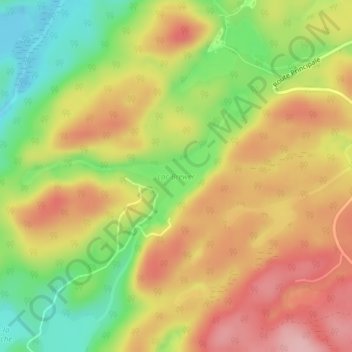
Name: Lac Brewer topographic map, elevation, terrain.
Average elevation: 349 m
Minimum elevation: 264 m
Maximum elevation: 424 m
Thank you for supporting this site ❤️
Make a donation
Make a donation
Other topographic maps
Click on a map to view its topography, its elevation and its terrain.
Lac Saint-François-Xavier
Canada > Québec > Les Pays-d'en-Haut > Wentworth-Nord > Montfort
Average elevation: 426 m