
Thank you for supporting this site ❤️
Make a donation
Make a donation
Les Berthets topographic map
Click on the map to display elevation.
Thank you for supporting this site ❤️
Make a donation
Make a donation
About this map
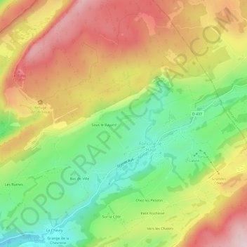
Name: Les Berthets topographic map, elevation, terrain.
Average elevation: 999 m
Minimum elevation: 817 m
Maximum elevation: 1,191 m
Thank you for supporting this site ❤️
Make a donation
Make a donation
Other topographic maps
Click on a map to view its topography, its elevation and its terrain.
Paroisse des Foncines
France > Bourgogne – Franche-Comté > Jura > Foncine-le-Haut
Average elevation: 995 m